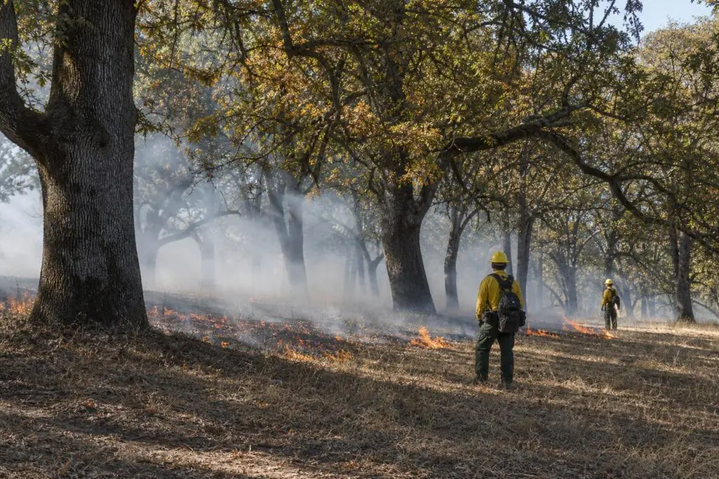
A prescribed burn on 4.3 acres of private oak woodland north of Corvallis, Oregon, gave a newly formed local association its first opportunity to put years of landowner preparation into practice. The Oct. 3 operation combined habitat restoration with hands-on training, bringing experienced fire practitioners together with people developing prescribed-fire skills.
Oregon State University Extension described the operation in an Oct. 29 report. The Mid-Willamette Prescribed Burn Association, formed in early 2025, completed its first private-land burn in Benton County under a state-certified burn manager, with trained personnel and firefighting resources on site. Its broader work spans Benton, Linn, Polk and Marion counties.
The project offers a recent example of the coordination behind woodland burning. A separate OSU Extension case study, published in 2018 about a May 2016 underburn near Trail, Oregon, adds a longer view of preparation and measured effects. The projects involved different forests and objectives, but both placed substantial work ahead of ignition.
Restoring habitat while building skills
At the Corvallis-area property, landowners had prepared the site for years. The association also spent more than a year developing skills and relationships before the burn, according to OSU Extension. The university’s Extension Fire Program co-founded the association; regional fire specialist Kayla Bordelon and fire program manager Carrie Berger serve on its steering committee.
The ecological goal was to maintain the open conditions characteristic of oak woodland. OSU Extension explains that prescribed fire can reduce accumulated vegetation and woody encroachment while supporting native plants and wildlife. Indigenous peoples regularly used fire to steward Willamette Valley prairies and oak woodlands before colonization. Disruption of those practices, fire exclusion and land-use changes altered those landscapes.
Organizers sought to consume more than 80% of grasses, leaf litter and other surface fuels, along with at least 60% of shrubs and small woody debris, while largely avoiding live-tree mortality. Paul Catino, the burn’s lead organizer and an OSU forestry master’s student, reported high surface-fuel consumption, reduced undesirable shrubs and almost no tree mortality in initial estimates made two days afterward. Those observations were early results, not a long-term vegetation assessment.
Getting the operation underway required suitable weather, fuel conditions and smoke dispersion to coincide with available crews and equipment. OSU Extension described the region’s opportunity as relatively short, often in fall. Multiple engines, more than 20 staff members, landowners and more than 15 volunteers supported the October burn. Experienced practitioners worked alongside learners, making training part of the treatment itself.
A historical case built on repeated thinning
The older project took place in a dry mixed-conifer forest, not the oak habitat near Corvallis. In their 2018 case study, Max Bennett and Marty Main described a 36-acre underburn on Marty and Peggy Main’s 120-acre property near Trail. The owners sought mature forest conditions, multiple tree species and age classes, reduced potential for severe wildfire, and income from logs and forest byproducts.
Repeated thinning preceded that burn. Removing smaller trees raised the height of remaining crowns and reduced ladder fuels, the vegetation that can carry fire upward. Thinned material went into poles and firewood, while some heavier concentrations were pile-burned. Eleven acres had also been underburned roughly two decades earlier. These treatments established the conditions for the 2016 operation rather than leaving fire to address all accumulated fuels at once.
The project also crossed a property boundary. A neighboring Bureau of Land Management parcel received thinning and underburning, and an agreement with the agency connected the private treatment with its work along a strategic ridgeline. The owners and specialists developed objectives that included reducing fuels, retaining protective litter and duff, and preserving wildlife habitat, particularly large, old black oaks.
An experienced 12-person BLM crew conducted the burn on May 10, 2016. Crews monitored weather, fuel moisture and ventilation, then adjusted ignition as conditions changed. Bennett and Main reported that crews reduced ignition intensity when fire behavior on some upper slopes threatened to become more intense than intended.
Measured benefits, uneven effects
Monitoring documented both fuel reduction and uneven effects. The measured smaller woody fuels fell to 39% of preburn amounts. Burn severity averaged 0.73 on a zero-to-three scale across 18 sampling points, within the study’s low-severity range. Some ground did not burn, while other patches burned more intensely.
Low average severity did not mean an absence of tree losses. Mapped patches of crown scorch and mortality covered about 2.5 acres within the 36-acre unit. Permanent-plot monitoring found 128 trees per acre killed or heavily damaged, mostly smaller trees. Stand basal area, a measure of tree cross-sectional area, declined 10%.
The historical measurements describe one prepared mixed-conifer stand, not a forecast for the recent oak project. Near Corvallis, Catino identified spring vegetation response as something organizers looked forward to observing. That next season will extend the picture beyond the initial two-day assessment of fuel consumption and tree survival.